
Thank you for supporting this site ❤️
Make a donation
Make a donation
La Ribeyre topographic map
Click on the map to display elevation.
Thank you for supporting this site ❤️
Make a donation
Make a donation
About this map
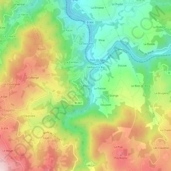
Name: La Ribeyre topographic map, elevation, terrain.
Average elevation: 626 m
Minimum elevation: 455 m
Maximum elevation: 836 m
Thank you for supporting this site ❤️
Make a donation
Make a donation
Other topographic maps
Click on a map to view its topography, its elevation and its terrain.
63590
France > Auvergne-Rhône-Alpes > Puy-de-Dôme > La Chapelle-Agnon > La Gardette
Average elevation: 701 m