
Make a donation
Bastrop County topographic map
Click on the map to display elevation.
Make a donation
Bastrop County
According to the U.S. Census Bureau, the county has a total area of 896 square miles (2,320 km2), of which 888 square miles (2,300 km2) are land and 7.4 square miles (19 km2) (0.8%) are covered by water. This area resides in the Gulf Coastal Plains which has sparse topographic relief; elevations gently slope between 400-600 feet. Vegetation is primarily Post Oak savannah and woodland, Blackland Prairie, and pine hardwood forest. The unique Lost Pines Forest features Loblolly pine (Pinus taeda) which require the deep, moist, acidic, sandy soil of the Carrizo Sands formation.
Make a donation
About this map
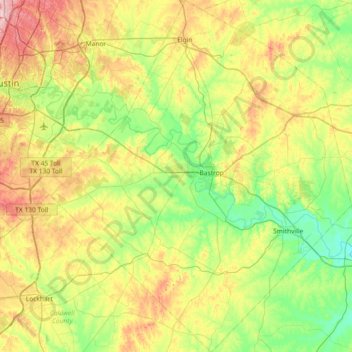
Name: Bastrop County topographic map, elevation, terrain.
Location: Bastrop County, Texas, United States (29.78652 -97.64906 30.41967 -97.02440)
Average elevation: 149 m
Minimum elevation: 81 m
Maximum elevation: 280 m
Make a donation
Other topographic maps
Click on a map to view its topography, its elevation and its terrain.
Make a donation
Georgetown
United States > Texas > Georgetown
The city is located on the northeastern edge of Texas Hill Country. Portions of Georgetown are located on either side of the Balcones Escarpment, a fault line in which the areas roughly east of IH-35 are flat and characterized by having black, fertile soils of the Blackland Prairie, and the west side of the…
Average elevation: 219 m
Make a donation
Make a donation
Make a donation
Make a donation
Make a donation
Make a donation
Make a donation
Make a donation
Enchanted Rock
United States > Texas > Llano County
Enchanted Rock is a pink granite mountain located in the Llano Uplift about 17 miles (27 km) north of Fredericksburg, Texas and 24 miles (39 km) south of Llano, Texas, United States. Enchanted Rock State Natural Area, which includes Enchanted Rock and surrounding land, spans the border between Gillespie and…
Average elevation: 453 m
Padre Island National Seashore
United States > Texas > Kenedy County > Corpus Christi
Average elevation: 5 m
Make a donation
Make a donation
Make a donation
Make a donation
Make a donation
Make a donation
Make a donation
Make a donation
Make a donation
Make a donation
Make a donation
Choke Canyon State Park - Calliham Unit
United States > Texas > McMullen County > Calliham
Average elevation: 67 m
Make a donation
Make a donation
Mineral Wells Fossil Park
United States > Texas > Palo Pinto County > Mineral Wells
Average elevation: 283 m
Make a donation
Rio Vista Addition Colonia
United States > Texas > El Paso County > Socorro
Average elevation: 1,116 m
Make a donation
Sierra Blanca
United States > Texas > Hudspeth County
Sierra Blanca is found in Far West Texas, a subdivision of West Texas, and is 4,520 feet (1,380 m) above sea level. The town is part of the Trans-Pecos region within the most mountainous and arid portion of Texas. The town is located in Hudspeth County, which is large and sparsely populated. Sierra Blanca…
Average elevation: 1,391 m
Make a donation