
Chungcheongnam-do topographic map
Interactive map
Click on the map to display elevation.
About this map
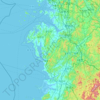
Name: Chungcheongnam-do topographic map, elevation, terrain.
Location: Chungcheongnam-do, South Korea (35.97813 125.28828 37.09605 127.63959)
Average elevation: 89 m
Minimum elevation: -3 m
Maximum elevation: 1,560 m
At 845 metres, Mount Gyeryong is the most notable elevation. It is located in a national park which is noted for its unique rock features. Apart from the stone formations there are a number of old temples. These include Gwanchok-sa, a temple which is home to the largest stone Buddha in Korea. In 1978 the Taean Marine National Park was opened. It includes some of the country's best bathing beaches, and Cheollipo Arboretum which was created in 1966 by C. Ferris Miller and contains approximately 14,000 different plant species, including some rare and endangered species.