
Thank you for supporting this site ❤️
Make a donation
Make a donation
Ranier topographic map
Click on the map to display elevation.
Thank you for supporting this site ❤️
Make a donation
Make a donation
About this map
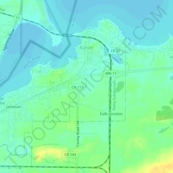
Name: Ranier topographic map, elevation, terrain.
Location: Ranier, Koochiching County, Minnesota, 56668, United States (48.59619 -93.37246 48.61761 -93.33944)
Average elevation: 342 m
Minimum elevation: 334 m
Maximum elevation: 358 m
Thank you for supporting this site ❤️
Make a donation
Make a donation
Other topographic maps
Click on a map to view its topography, its elevation and its terrain.
South International Falls
United States > Minnesota > Koochiching County > International Falls
Average elevation: 349 m