
Asheville topographic map
Interactive map
Click on the map to display elevation.
About this map
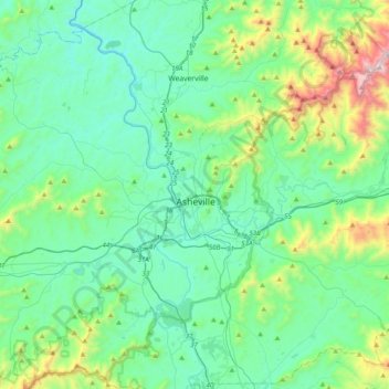
Name: Asheville topographic map, elevation, terrain.
Average elevation: 774 m
Minimum elevation: 523 m
Maximum elevation: 1,815 m
Other topographic maps
Click on a map to view its topography, its elevation and its terrain.
West Asheville
United States of America > North Carolina > Asheville > West Asheville
West Asheville, Asheville, Buncombe County, North Carolina, 28806, United States of America
Average elevation: 634 m