
Thank you for supporting this site ❤️
Make a donation
Make a donation
Korolevu topographic map
Click on the map to display elevation.
Thank you for supporting this site ❤️
Make a donation
Make a donation
About this map
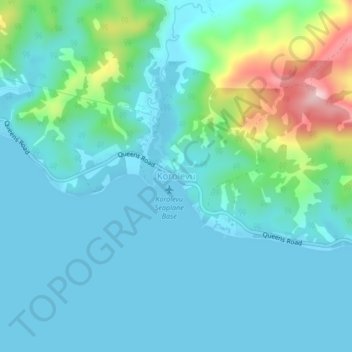
Name: Korolevu topographic map, elevation, terrain.
Location: Korolevu, Nadroga-Navosa, Western, Fiji (-18.23407 177.71060 -18.19407 177.75060)
Average elevation: 50 m
Minimum elevation: 0 m
Maximum elevation: 278 m
Thank you for supporting this site ❤️
Make a donation
Make a donation
Other topographic maps
Click on a map to view its topography, its elevation and its terrain.