
Saratoga Springs topographic map
Interactive map
Click on the map to display elevation.
About this map
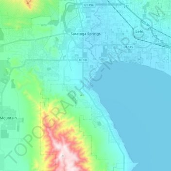
Name: Saratoga Springs topographic map, elevation, terrain.
Location: Saratoga Springs, Utah County, Utah, 84045, United States (40.26063 -111.97839 40.41673 -111.85576)
Average elevation: 1,500 m
Minimum elevation: 1,365 m
Maximum elevation: 2,339 m
Saratoga Springs is a city in Utah County, Utah, United States. The elevation is 4,505 feet. It is part of the Provo–Orem, Utah Metropolitan Statistical Area. The city is a relatively new development along the northwestern shores of Utah Lake. It was incorporated on December 31, 1997 and has been growing rapidly since then. The population was 37,696 at the 2020 Census. Saratoga Springs became a city in 2001.
Other topographic maps
Click on a map to view its topography, its elevation and its terrain.
Provo
United States > Utah > Utah County
Provo, Utah County, Utah, United States
Average elevation: 1,728 m
Woodland Hills
United States > Utah > Utah County
Woodland Hills, Utah County, Utah, United States
Average elevation: 1,812 m
Mount Timpanogos
United States > Utah > Utah County
Mount Timpanogos, Utah County, Utah, 84602, United States
Average elevation: 3,139 m
Elk Ridge
United States > Utah > Utah County
Elk Ridge, Utah County, Utah, United States
Average elevation: 1,698 m
Townsend
United States > Utah > Utah County > Genola
Townsend, Genola, Utah County, Utah, 84655, United States
Average elevation: 1,438 m
Pleasant View
United States > Utah > Utah County > Provo
Pleasant View, Provo, Utah County, Utah, 84604, United States
Average elevation: 1,446 m
Salem
United States > Utah > Utah County
Salem, Utah County, Utah, 84653, United States
Average elevation: 1,473 m
Lehi
United States > Utah > Utah County
Lehi, Utah County, Utah, 84043, United States
Average elevation: 1,465 m
Lone Peak
United States > Utah > Utah County
Lone Peak, Utah County, Utah, 84092, United States
Average elevation: 3,013 m
Springville
United States > Utah > Utah County
Springville, Utah County, Utah, 84663, United States
Average elevation: 1,566 m
Pleasant Grove
United States > Utah > Utah County
Pleasant Grove, Utah County, Utah, 84062, United States
Average elevation: 1,578 m
Eagle Mountain
United States > Utah > Utah County
Eagle Mountain, Utah County, Utah, 84005, United States
Average elevation: 1,589 m
Vineyard
United States > Utah > Utah County
Vineyard, Utah County, Utah, 84059, United States
Average elevation: 1,382 m
Santaquin
United States > Utah > Utah County > Santaquin
Santaquin, Utah County, Utah, 84655, United States
Average elevation: 1,701 m
Orem
United States > Utah > Utah County
Orem, Utah County, Utah, United States
Average elevation: 1,457 m
Lindon
United States > Utah > Utah County
Lindon, Utah County, Utah, 84042, United States
Average elevation: 1,537 m
Payson
United States > Utah > Utah County > Payson
Payson, Utah County, Utah, 84651, United States
Average elevation: 1,473 m