
Thank you for supporting this site ❤️
Make a donation
Make a donation
Kodaikanal topographic map
Click on the map to display elevation.
Thank you for supporting this site ❤️
Make a donation
Make a donation
About this map
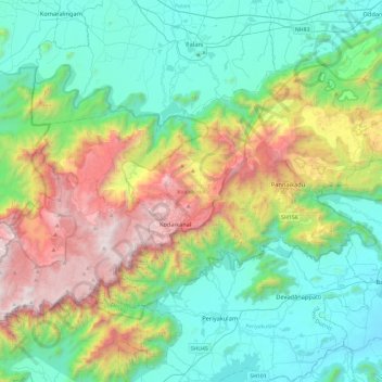
Name: Kodaikanal topographic map, elevation, terrain.
Location: Kodaikanal, Dindigul District, Tamil Nadu, India (10.11691 77.26649 10.43050 77.73587)
Average elevation: 869 m
Minimum elevation: 218 m
Maximum elevation: 2,502 m
Thank you for supporting this site ❤️
Make a donation
Make a donation
Other topographic maps
Click on a map to view its topography, its elevation and its terrain.
Udhagamandalam
India > Tamil Nadu > Udhagamandalam
Ooty is located in the Nilgiri hills, which form a part of the Western Ghats in the Nilgiri Biosphere Reserve. It is separated from the neighboring state of Karnataka by the Moyar river in the north and from the Anaimalai and Palani hills in the south by the Palghat Gap. It is situated at an altitude of 2,240…
Average elevation: 2,234 m
Thank you for supporting this site ❤️
Make a donation
Make a donation