
Thank you for supporting this site ❤️
Make a donation
Make a donation
Mid-Coast Council topographic map
Click on the map to display elevation.
Thank you for supporting this site ❤️
Make a donation
Make a donation
About this map
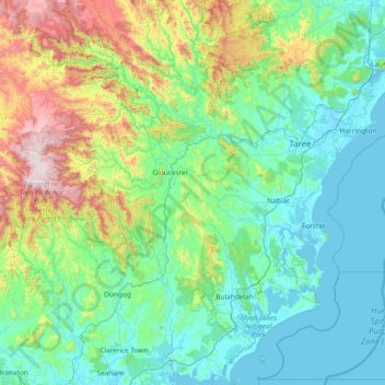
Name: Mid-Coast Council topographic map, elevation, terrain.
Location: Mid-Coast Council, New South Wales, Australia (-32.70196 151.40285 -31.44240 152.80521)
Average elevation: 278 m
Minimum elevation: -3 m
Maximum elevation: 1,575 m
Thank you for supporting this site ❤️
Make a donation
Make a donation
Other topographic maps
Click on a map to view its topography, its elevation and its terrain.
Thank you for supporting this site ❤️
Make a donation
Make a donation
Thank you for supporting this site ❤️
Make a donation
Make a donation
Thank you for supporting this site ❤️
Make a donation
Make a donation
Thank you for supporting this site ❤️
Make a donation
Make a donation