
Thank you for supporting this site ❤️
Make a donation
Make a donation
Mount Warren Park topographic map
Click on the map to display elevation.
Thank you for supporting this site ❤️
Make a donation
Make a donation
About this map
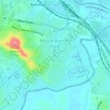
Name: Mount Warren Park topographic map, elevation, terrain.
Location: Mount Warren Park, Logan City, Queensland, 4207, Australia (-27.74002 153.19198 -27.72155 153.21992)
Average elevation: 15 m
Minimum elevation: 0 m
Maximum elevation: 97 m
Thank you for supporting this site ❤️
Make a donation
Make a donation
Other topographic maps
Click on a map to view its topography, its elevation and its terrain.