
Skipton topographic map
Interactive map
Click on the map to display elevation.
About this map
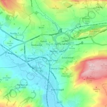
Name: Skipton topographic map, elevation, terrain.
Location: Skipton, Craven, North Yorkshire, England, United Kingdom (53.93958 -2.04957 53.98142 -1.94936)
Average elevation: 173 m
Minimum elevation: 89 m
Maximum elevation: 367 m
Other topographic maps
Click on a map to view its topography, its elevation and its terrain.
Linton
United Kingdom > England > North Yorkshire > Craven
Grassington, Linton, Craven, North Yorkshire, England, United Kingdom
Average elevation: 310 m
Craven
United Kingdom > England > North Yorkshire > Craven
Craven, North Yorkshire, Yorkshire and the Humber, England, United Kingdom
Average elevation: 294 m
Thornydale Laithe
United Kingdom > England > North Yorkshire > Craven > Calton
Thornydale Laithe, Calton, Craven, North Yorkshire, Yorkshire and the Humber, England, BD23 3QP, United Kingdom
Average elevation: 179 m