
Trearddur topographic map
Click on the map to display elevation.
About this map
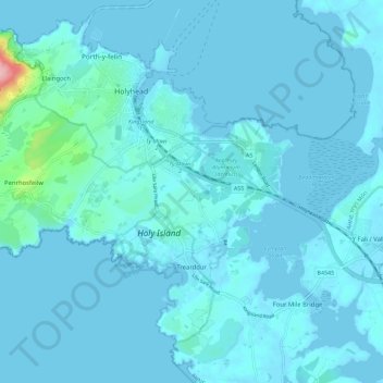
Name: Trearddur topographic map, elevation, terrain.
Location: Trearddur, Isle of Anglesey, Wales, United Kingdom (53.26201 -4.69671 53.32364 -4.58331)
Average elevation: 9 m
Minimum elevation: -1 m
Maximum elevation: 161 m
Other topographic maps
Click on a map to view its topography, its elevation and its terrain.
Llanfihangel yn Nhowyn
United Kingdom > Wales > Isle of Anglesey > Caergeiliog
Average elevation: 13 m