
Thank you for supporting this site ❤️
Make a donation
Make a donation
Santa Cruz topographic map
Click on the map to display elevation.
Thank you for supporting this site ❤️
Make a donation
Make a donation
About this map
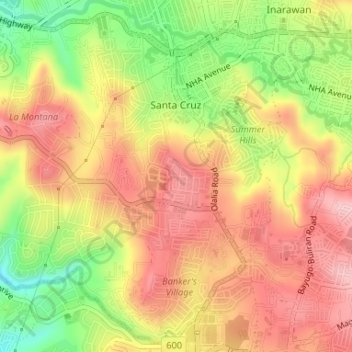
Name: Santa Cruz topographic map, elevation, terrain.
Location: Santa Cruz, Antipolo, Rizal, Calabarzon, 1870, Philippines (14.59447 121.14327 14.62470 121.17610)
Average elevation: 140 m
Minimum elevation: 22 m
Maximum elevation: 239 m
Thank you for supporting this site ❤️
Make a donation
Make a donation
Other topographic maps
Click on a map to view its topography, its elevation and its terrain.