
Thank you for supporting this site ❤️
Make a donation
Make a donation
Karbubu topographic map
Click on the map to display elevation.
Thank you for supporting this site ❤️
Make a donation
Make a donation
About this map
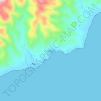
Name: Karbubu topographic map, elevation, terrain.
Location: Karbubu, Maluku Barat Daya, Maluku, Indonesia (-7.99777 125.83633 -7.95777 125.87633)
Average elevation: 63 m
Minimum elevation: 0 m
Maximum elevation: 393 m
Thank you for supporting this site ❤️
Make a donation
Make a donation
Other topographic maps
Click on a map to view its topography, its elevation and its terrain.
Thank you for supporting this site ❤️
Make a donation
Make a donation
Thank you for supporting this site ❤️
Make a donation
Make a donation