
Thank you for supporting this site ❤️
Make a donation
Make a donation
Cepoko topographic map
Click on the map to display elevation.
Thank you for supporting this site ❤️
Make a donation
Make a donation
About this map
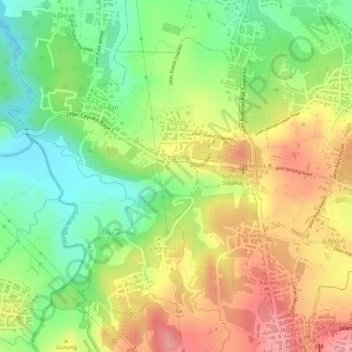
Name: Cepoko topographic map, elevation, terrain.
Location: Cepoko, Gunung Pati, Semarang, Central Java, Java, Indonesia (-7.08517 110.34222 -7.06398 110.36002)
Average elevation: 247 m
Minimum elevation: 189 m
Maximum elevation: 302 m
Thank you for supporting this site ❤️
Make a donation
Make a donation
Other topographic maps
Click on a map to view its topography, its elevation and its terrain.
Thank you for supporting this site ❤️
Make a donation
Make a donation
Thank you for supporting this site ❤️
Make a donation
Make a donation
Thank you for supporting this site ❤️
Make a donation
Make a donation
Thank you for supporting this site ❤️
Make a donation
Make a donation