
Thank you for supporting this site ❤️
Make a donation
Make a donation
Alabat topographic map
Click on the map to display elevation.
Thank you for supporting this site ❤️
Make a donation
Make a donation
About this map
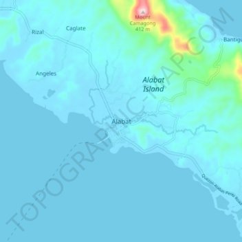
Name: Alabat topographic map, elevation, terrain.
Location: Alabat, Quezon, Calabarzon, Philippines (14.06579 121.97472 14.14579 122.05472)
Average elevation: 25 m
Minimum elevation: -2 m
Maximum elevation: 400 m
Thank you for supporting this site ❤️
Make a donation
Make a donation
Other topographic maps
Click on a map to view its topography, its elevation and its terrain.
Thank you for supporting this site ❤️
Make a donation
Make a donation
Thank you for supporting this site ❤️
Make a donation
Make a donation