
Thank you for supporting this site ❤️
Make a donation
Make a donation
Río Tambo topographic map
Click on the map to display elevation.
Thank you for supporting this site ❤️
Make a donation
Make a donation
About this map
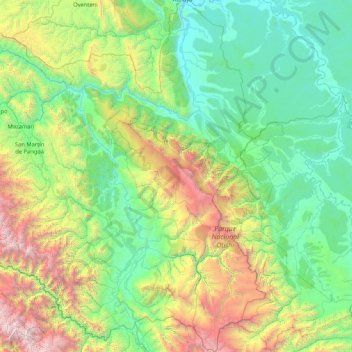
Name: Río Tambo topographic map, elevation, terrain.
Location: Río Tambo, Satipo, Junín, Perú (-12.38699 -74.70202 -10.73401 -73.35513)
Average elevation: 1,174 m
Minimum elevation: 205 m
Maximum elevation: 4,901 m
Thank you for supporting this site ❤️
Make a donation
Make a donation
Other topographic maps
Click on a map to view its topography, its elevation and its terrain.