
Thank you for supporting this site ❤️
Make a donation
Make a donation
Toce / Tosa topographic map
Click on the map to display elevation.
Thank you for supporting this site ❤️
Make a donation
Make a donation
About this map
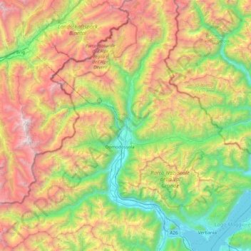
Name: Toce / Tosa topographic map, elevation, terrain.
Location: Toce / Tosa, Piemont, 28866, Italy (45.89436 8.26527 46.42509 8.57654)
Average elevation: 1,568 m
Minimum elevation: 186 m
Maximum elevation: 3,987 m
Thank you for supporting this site ❤️
Make a donation
Make a donation
Other topographic maps
Click on a map to view its topography, its elevation and its terrain.
Thank you for supporting this site ❤️
Make a donation
Make a donation
Thank you for supporting this site ❤️
Make a donation
Make a donation
Tetto Battista Massa
Italy > Piemont > Cuneo > Roccavione > Tetto Battista Massa
Average elevation: 758 m
Marmorito Santa Maria
Italy > Piemont > Asti > Aramengo > Marmorito Santa Maria
Average elevation: 329 m
Fubine Monferrato
Italy > Piemont > Alessandria > Fubine Monferrato > Fubine Monferrato
Average elevation: 167 m
Thank you for supporting this site ❤️
Make a donation
Make a donation