
Thank you for supporting this site ❤️
Make a donation
Make a donation
Harderwijk topographic map
Click on the map to display elevation.
Thank you for supporting this site ❤️
Make a donation
Make a donation
About this map
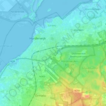
Name: Harderwijk topographic map, elevation, terrain.
Location: Harderwijk, Gelderland, Nederland (52.30154 5.56586 52.37086 5.71285)
Average elevation: 7 m
Minimum elevation: -6 m
Maximum elevation: 34 m
Thank you for supporting this site ❤️
Make a donation
Make a donation
Other topographic maps
Click on a map to view its topography, its elevation and its terrain.