
Thank you for supporting this site ❤️
Make a donation
Make a donation
Vals topographic map
Click on the map to display elevation.
Thank you for supporting this site ❤️
Make a donation
Make a donation
About this map
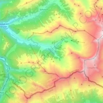
Name: Vals topographic map, elevation, terrain.
Location: Vals, Bezirk Innsbruck-Land, Austria (47.00539 11.48867 47.06322 11.65072)
Average elevation: 2,066 m
Minimum elevation: 1,119 m
Maximum elevation: 3,392 m
Thank you for supporting this site ❤️
Make a donation
Make a donation
Other topographic maps
Click on a map to view its topography, its elevation and its terrain.