
Reims topographic map
Interactive map
Click on the map to display elevation.
About this map
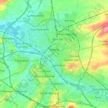
Name: Reims topographic map, elevation, terrain.
Location: Reims, Marne, Grande Leste, França metropolitana, 51100, França (49.20394 3.98582 49.30319 4.12970)
Average elevation: 96 m
Minimum elevation: 70 m
Maximum elevation: 166 m
Other topographic maps
Click on a map to view its topography, its elevation and its terrain.
Saint-Chéron
França > Grande Leste > Marne
Saint-Chéron, Vitry-le-François, Marne, Grande Leste, França metropolitana, 51290, França
Average elevation: 140 m