
Brixen - Bressanone topographic map
Interactive map
Click on the map to display elevation.
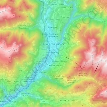
Brixen - Bressanone topographic map, elevation, terrain
About this map
Name: Brixen - Bressanone topographic map, elevation, terrain.
Average elevation: 1,307 m
Minimum elevation: 512 m
Maximum elevation: 2,556 m
Other topographic maps
Click on a map to view its topography, its elevation and its terrain.
Bolzano - Bozen
Italy > Trentino – Alto Adige/Südtirol > South Tyrol
The area of the city of Bolzano is 52.3 km2 (20.2 sq mi), of which 28 km2 (11 sq mi) is used as a settlement area. The city is located in the basin where the Sarntal, Eisacktal, and the Adige Valley with their rivers, Talfer, Eisack, and Adige, meet. In the Middle Ages, the two main Alpine crossings, the Via…
Average elevation: 716 m
Obermais - Maia Alta
Italy > Trentino – Alto Adige/Südtirol > South Tyrol > Meran - Merano
Average elevation: 483 m