
Thank you for supporting this site ❤️
Make a donation
Make a donation
Kattakkada topographic map
Click on the map to display elevation.
Thank you for supporting this site ❤️
Make a donation
Make a donation
About this map
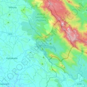
Name: Kattakkada topographic map, elevation, terrain.
Location: Kattakkada, Thiruvananthapuram, Kerala, India (8.43447 77.00227 8.67382 77.28343)
Average elevation: 336 m
Minimum elevation: 14 m
Maximum elevation: 1,817 m
Thank you for supporting this site ❤️
Make a donation
Make a donation
Other topographic maps
Click on a map to view its topography, its elevation and its terrain.
Vagamon
Vagamon, due to its elevation and climate, has a unique ecosystem, leading to the emergence of rich natural vegetation, plant species, shola forests etc. From the early 20th century plantation grew crops like tea and coffee. Vagamon hills are home to less explored flora and fauna. A diversity study conducted…
Average elevation: 866 m
Thank you for supporting this site ❤️
Make a donation
Make a donation
Thank you for supporting this site ❤️
Make a donation
Make a donation