
Thank you for supporting this site ❤️
Make a donation
Make a donation
Tayoltita topographic map
Click on the map to display elevation.
Thank you for supporting this site ❤️
Make a donation
Make a donation
About this map
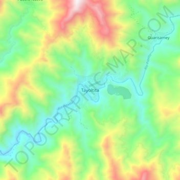
Name: Tayoltita topographic map, elevation, terrain.
Location: Tayoltita, San Dimas, Durango, México (24.06687 -105.96506 24.14687 -105.88506)
Average elevation: 951 m
Minimum elevation: 462 m
Maximum elevation: 1,904 m
Thank you for supporting this site ❤️
Make a donation
Make a donation