Xuzhou topographic map
Interactive map
Click on the map to display elevation.
Xuzhou topographic map, elevation, terrain
About this map
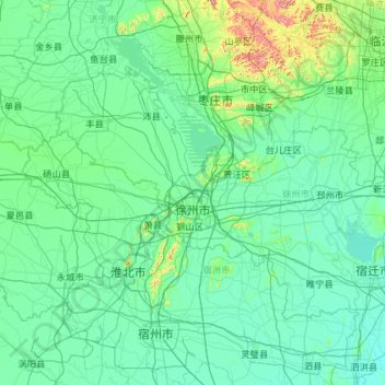
Name: Xuzhou topographic map, elevation, terrain.
Location: Xuzhou, Jiangsu, China (33.71239 116.35520 34.97567 118.66874)
Average elevation: 50 m
Minimum elevation: 12 m
Maximum elevation: 614 m
Other topographic maps
Click on a map to view its topography, its elevation and its terrain.
Nanjing City
There are mainly two types of soil in Nanjing: zonal soil and cultivated soil. The zonal soil is yellow-brown soil in the northern and central areas of Nanjing, and red soil in the southern part of the border with Anhui. The cultivated soil formed by human-made farming is mainly paddy soil, and there are some…
Average elevation: 28 m