
Pohnpei topographic map
Interactive map
Click on the map to display elevation.
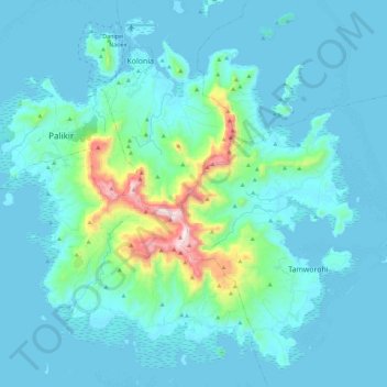
Pohnpei topographic map, elevation, terrain
About this map
Name: Pohnpei topographic map, elevation, terrain.
Average elevation: 87 m
Minimum elevation: -1 m
Maximum elevation: 782 m
Other topographic maps
Click on a map to view its topography, its elevation and its terrain.
Palikir
Federated States of Micronesia > Pohnpei > Sokehs > Palikir
Palikir is located in the northwestern center of Pohnpei Island (formerly known as Ponape). Geologically the island terrain consists of high mountains to low coral atolls. It is the largest, highest, wettest and most scenic island of the Federated States of Micronesia. Palikir is 8 kilometers (5 miles)…
Average elevation: 118 m