
Pļaviņas topographic map
Interactive map
Click on the map to display elevation.
About this map
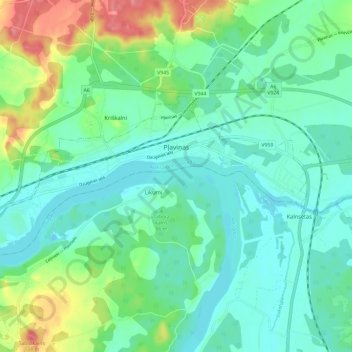
Name: Pļaviņas topographic map, elevation, terrain.
Location: Pļaviņas, Pļaviņu novads, Zemgale, LV-5120, Latvia (56.60274 25.68664 56.62818 25.78554)
Average elevation: 89 m
Minimum elevation: 69 m
Maximum elevation: 153 m
Other topographic maps
Click on a map to view its topography, its elevation and its terrain.
Liepziedi
Latvia > Zemgale > Dobeles novads > Auru pagasts
Liepziedi, Auru pagasts, Dobeles novads, Zemgale, LV-3701, Latvia
Average elevation: 58 m