Donsol topographic map
Interactive map
Click on the map to display elevation.
Donsol topographic map, elevation, terrain
About this map
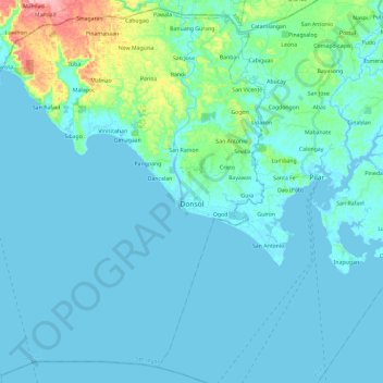
Name: Donsol topographic map, elevation, terrain.
Location: Donsol, Sorsogon, Bicol Region, 4715, Philippines (12.80505 123.40830 13.02482 123.64332)
Average elevation: 19 m
Minimum elevation: -2 m
Maximum elevation: 161 m
Other topographic maps
Click on a map to view its topography, its elevation and its terrain.
Irosin
The place had been an undisturbed sanctuary for wildlife until settlers from Bulusan came in search of wild quarry and rattan. These pioneers, using the slash-and-burn method, cleared a settlement beside a river which gave birth to a clearing called Hin-ay, an Albayanon word which denotes the arrangement of…
Average elevation: 152 m
Sorsogon City
Sorsogon City covers a land area of 31,292 hectares (120.82 sq mi). It is at the southernmost tip of the Bicol Peninsula and of Luzon Island. The city is bounded by Castilla in the west, Manito in the northwest, Albay Gulf in the north, Prieto Diaz in the east, Gubat in the southeast, Casiguran in the…
Average elevation: 89 m