
Fall City topographic map
Interactive map
Click on the map to display elevation.
Fall City topographic map, elevation, terrain
Fall City
The Fall City Airport is a small private airport community located 2 miles (3 km) east of the community at latitude 47-33-34.366 N and longitude 121-51-49.413 W, at an elevation of 140 feet (43 m) above sea level. The airport is owned by the Fall City Airport Association. It has no air traffic control tower.
About this map
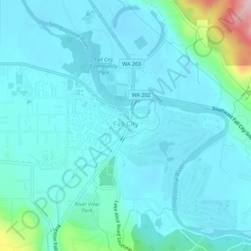
Name: Fall City topographic map, elevation, terrain.
Location: Fall City, King County, Washington, 98024, United States (47.55409 -121.92178 47.57775 -121.88331)
Average elevation: 49 m
Minimum elevation: 20 m
Maximum elevation: 231 m