
Greenville County topographic map
Interactive map
Click on the map to display elevation.
About this map
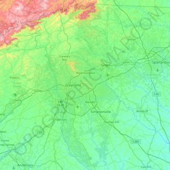
Name: Greenville County topographic map, elevation, terrain.
Location: Greenville County, South Carolina, United States of America (34.48406 -82.76441 35.21549 -82.14696)
Average elevation: 308 m
Minimum elevation: 135 m
Maximum elevation: 1,130 m
Other topographic maps
Click on a map to view its topography, its elevation and its terrain.
Ashley Forest
United States of America > South Carolina > Ashley Forest
Ashley Forest, Charleston County, South Carolina, 29407, United States of America
Average elevation: 3 m