
Make a donation
Copperton topographic map
Click on the map to display elevation.
Make a donation
About this map
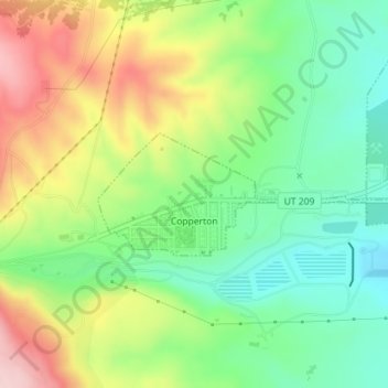
Name: Copperton topographic map, elevation, terrain.
Location: Copperton, Salt Lake County, Utah, United States (40.56229 -112.10629 40.57080 -112.07918)
Average elevation: 1,689 m
Minimum elevation: 1,593 m
Maximum elevation: 1,831 m
Make a donation
Other topographic maps
Click on a map to view its topography, its elevation and its terrain.
Salt Lake City
United States > Utah > Salt Lake County > Salt Lake City
Salt Lake City has an area of 110.4 square miles (286 km2) and an average elevation of 4,327 feet (1,319 m) above sea level. The lowest point within the boundaries of the city is 4,210 feet (1,280 m) near the Jordan River and the Great Salt Lake, and the highest is Grandview Peak, at 9,410 feet (2,868 m).
Average elevation: 1,625 m
Make a donation
Little Cottonwood Creek Valley
United States > Utah > Salt Lake County > Cottonwood Heights
Average elevation: 1,437 m
Make a donation
Make a donation
Draper
United States > Utah > Salt Lake County > Draper > Draper
Draper's climate is roughly identical to that of other Salt Lake City suburbs. However, due to being further away from the Great Salt Lake, varied elevation, and from the downtown urban heat island effect, Draper experiences a slightly drier winter, and more extremes in temperatures.
Average elevation: 1,464 m
Parleys Canyon
United States > Utah > Salt Lake County > Millcreek
Parleys Canyon is a canyon located in the U.S. state of Utah. The canyon provides the route of Interstate 80 (I-80) (and previously the Lincoln Highway, U.S. Route 40, and a railroad) up the western slope of the Wasatch Mountains and is a relatively wide, straight canyon other than near its mouth. The mountain…
Average elevation: 1,577 m
Make a donation
Make a donation
Granite Park
United States > Utah > Salt Lake County > Sandy > Granite Crest
Average elevation: 1,534 m
Brighton
United States > Utah > Salt Lake County
Brighton has a high-altitude cold continental climate (Köppen Dsb/Dsc), with dry summers and very snowy winters.
Average elevation: 2,852 m
Make a donation
Make a donation
Hickory Valley
United States > Utah > Salt Lake County > Sandy > Hickory Valley
Average elevation: 1,534 m
Make a donation
West Valley City
United States > Utah > Salt Lake County > West Valley City
Average elevation: 1,492 m