
Thank you for supporting this site ❤️
Make a donation
Make a donation
Morgan County topographic map
Click on the map to display elevation.
Thank you for supporting this site ❤️
Make a donation
Make a donation
About this map
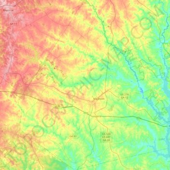
Name: Morgan County topographic map, elevation, terrain.
Location: Morgan County, Georgia, United States (33.43445 -83.68739 33.81776 -83.26920)
Average elevation: 194 m
Minimum elevation: 129 m
Maximum elevation: 285 m
Thank you for supporting this site ❤️
Make a donation
Make a donation
Other topographic maps
Click on a map to view its topography, its elevation and its terrain.