
Santorin topographic map
Interactive map
Click on the map to display elevation.
About this map
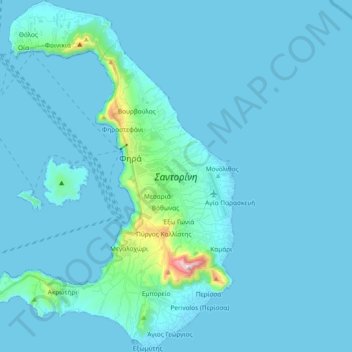
Name: Santorin topographic map, elevation, terrain.
Average elevation: 30 m
Minimum elevation: -1 m
Maximum elevation: 551 m
Von der 150 bis 350 m hohen Caldera-Wand ist die Abdachung von Thira und Thirasia nach außen hin sanft. Lediglich im Südosten von Thira unterbricht das Profitis-Ilias-Massiv, mit 567 m die höchste Erhebung des Archipels, diesen sanften Abfall. Vielerorts bildet ein breiter schwarzer Lavastrand den Übergang zum Meer. An anderen Stellen reicht die Bimsdecke bis ans Meer und bildet dann Steilküsten. Auf Thira mit Ausnahme des Profitis-Ilias-Massivs und auf Thirasia prägen tiefe Erosionsrinnen in der weichen Bimsdecke, verursacht durch winterliche Regenfälle, die Topographie.
Other topographic maps
Click on a map to view its topography, its elevation and its terrain.
Roter Strand
Griechenland > Ägäis > Regionalbezirk Thira > Δημοτική Ενότητα Θήρας > Akrotiri
Roter Strand, Akrotiri, Δημοτική Ενότητα Θήρας, Δήμος Θήρας, Regionalbezirk Thira, Region Südliche Ägäis, Ägäis, 84700, Griechenland
Average elevation: 38 m
Nea Kameni
Griechenland > Ägäis > Regionalbezirk Thira > Δημοτική Ενότητα Θήρας > Φηρά
Nea Kameni, Φηρά, Δημοτική Ενότητα Θήρας, Δήμος Θήρας, Regionalbezirk Thira, Region Südliche Ägäis, Ägäis, 847 00, Griechenland
Average elevation: 16 m