
Kerala topographic map
Interactive map
Click on the map to display elevation.
About this map
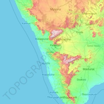
Name: Kerala topographic map, elevation, terrain.
Location: Kerala, India (8.29246 74.86383 12.79447 77.41194)
Average elevation: 251 m
Minimum elevation: -4 m
Maximum elevation: 2,557 m
Other topographic maps
Click on a map to view its topography, its elevation and its terrain.
Pulikkoottil Ukru Vaka Kulam
India > Kerala > Thrissur > Puthenpeedika
Pulikkoottil Ukru Vaka Kulam, Puthenpeedika, Thrissur, Thrissur district, Kerala, India
Average elevation: 6 m