
Make a donation
East Anglia topographic map
Click on the map to display elevation.
Make a donation
About this map
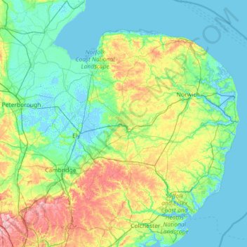
Name: East Anglia topographic map, elevation, terrain.
Location: East Anglia, England, United Kingdom (51.93176 -0.49990 52.99164 1.76891)
Average elevation: 29 m
Minimum elevation: -5 m
Maximum elevation: 185 m
Make a donation
Other topographic maps
Click on a map to view its topography, its elevation and its terrain.
Cambridge
United Kingdom > England > Cambridge
The city, like most of the UK, has a maritime climate highly influenced by the Gulf Stream. Located in the driest region of Britain, Cambridge's rainfall averages around 570 mm (22.44 in) per year, around half the national average, with some years occasionally falling into the semi-arid (under 500 mm (19.69…
Average elevation: 18 m
Castle Donington
United Kingdom > England > North West Leicestershire > Castle Donington
Average elevation: 62 m
Make a donation
Leeds
Lying in the eastern foothills of the Pennines, there is a significant variation in elevation within the city's built-up area. The district ranges from 1,115 feet (340 m) in the far west on the slopes of Ilkley Moor to about 33 feet (10 m) where the rivers Aire and Wharfe cross the eastern boundary. Land rises…
Average elevation: 94 m
Make a donation
Make a donation
Make a donation
Bedford
United Kingdom > England > Bedford
As with the rest of the United Kingdom, Bedford has a maritime climate, with a limited range of temperatures, and generally even rainfall throughout the year. The nearest Met Office weather station to Bedford is Bedford (Thurleigh) airport, about 6.5 miles (10.5 km) north of Bedford town centre at an elevation…
Average elevation: 37 m
Atherton
There were several ministers of note of Chowbent Chapel including James Wood, the "General" (1672–1759), who distinguished himself at the Battle of Preston in 1715. Thomas Walker Horsfield (1792–1837) was a historian and topographer. Joseph Nightingale (1775–1824), born in Chowbent, was a prolific…
Average elevation: 69 m
Make a donation
Bradford
Bradford is located at 53°45′00″N 01°50′00″W / 53.75000°N 1.83333°W / 53.75000; -1.83333 (53.7500, -1.8333)1. Topographically, it is located in the eastern moorland region of the South Pennines.
Average elevation: 167 m
Eltham
United Kingdom > England > Greater London
Eltham has a varied topography. Map 6 shows contours, spot heights and water courses. The centre of Eltham is on a plateau at about the 60m level with the High Street running along its centre. There is a scarp slope to the west of the plateau from the top of which are unrestricted views across South London.…
Average elevation: 48 m
Make a donation
Make a donation
Swindon
United Kingdom > England > Swindon
Swindon has an oceanic climate (Cfb in the Köppen climate classification), like the vast majority of the British Isles, with cool winters and warm summers. The nearest official weather station is RAF Lyneham, about 10 miles (16 km) west southwest of Swindon town centre. The weather station's elevation is 145…
Average elevation: 108 m
Tottenham
Tottenham's elevation is approximately 33 ft (10 m) above sea level.
Average elevation: 25 m
Make a donation
Bebington
Bebington is on the eastern side of the Wirral Peninsula, approximately 10 km (6.2 mi) south-south-east of the Irish Sea at New Brighton, about 7.5 km (4.7 mi) east-north-east of the Dee Estuary at Gayton and less than 2 km (1.2 mi) west-north-west of the River Mersey at New Ferry. The area is situated at an…
Average elevation: 28 m
Make a donation
New Ferry
New Ferry is on the eastern side of the Wirral Peninsula, on the western bank of the River Mersey. The area is approximately 9 km (5.6 mi) south-south-east of the Irish Sea at New Brighton and about 10 km (6.2 mi) east-north-east of the Dee Estuary at Heswall. The area lies at an elevation of between 0–27 m…
Average elevation: 25 m
Make a donation
Barden Lake
United Kingdom > England > Kent > Tonbridge and Malling > Tonbridge
Average elevation: 33 m
Make a donation
Make a donation
Tyldesley
At 53°30′59″N 2°28′0″W / 53.51639°N 2.46667°W / 53.51639; -2.46667 (53.5166°, −2.4668°), Tyldesley is situated eight miles (13 kilometres) east-southeast of Wigan and nine miles (14 kilometres) west-northwest of Manchester, and at the eastern end of the Metropolitan Borough of Wigan.…
Average elevation: 58 m
Make a donation
Make a donation
Putney
Putney Heath is around 400 acres (160 hectares) less the nascent A3 road in size and rises to 45 metres (148 ft) above sea level. Because of its elevation, from 1796 to 1816 Putney Heath hosted a station in the shutter telegraph chain, which connected the Admiralty in London to its naval ships in Portsmouth.…
Average elevation: 18 m
Make a donation
Make a donation
City of London
United Kingdom > England > City of London > City of London
The elevation of the City ranges from sea level at the Thames to 21.6 metres (71 ft) at the junction of High Holborn and Chancery Lane. Two small but notable hills are within the historic core, Ludgate Hill to the west and Cornhill to the east. Between them ran the Walbrook, one of the many "lost" rivers or…
Average elevation: 42 m
Slaithwaite
United Kingdom > England > Kirklees
In the 1848 edition of 'A Topographical Dictionary of England', Samuel Lewis (the editor) wrote:- "the lands are in meadow and pasture, with a small portion of arable; the scenery is bold and romantic. In the quarries of the district are found vegetable fossils, especially firs and other mountain trees. The…
Average elevation: 241 m
Make a donation
Make a donation
Hull
United Kingdom > England > Kingston upon Hull
Kingston upon Hull is on the northern bank of the Humber Estuary. The city centre is west of the River Hull and close to the Humber. The city is built upon alluvial and glacial deposits which overlie chalk rocks but the underlying chalk has no influence on the topography. The land within the city is generally…
Average elevation: 21 m
Make a donation
Make a donation
Make a donation
Make a donation
Make a donation
Make a donation
Make a donation