
Make a donation
Letchworth topographic map
Click on the map to display elevation.
Make a donation
About this map
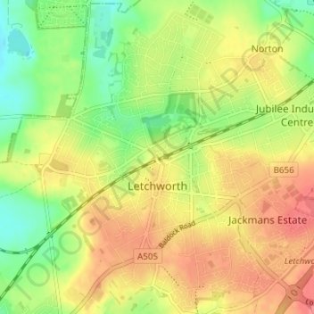
Name: Letchworth topographic map, elevation, terrain.
Location: Letchworth, Hertfordshire, England, United Kingdom (51.96105 -0.25510 51.99937 -0.19579)
Average elevation: 81 m
Minimum elevation: 48 m
Maximum elevation: 110 m
Make a donation
Other topographic maps
Click on a map to view its topography, its elevation and its terrain.
Make a donation
Spellbrook
United Kingdom > England > Hertfordshire > East Hertfordshire > Sawbridgeworth
Average elevation: 71 m
Make a donation
Make a donation
Make a donation
Make a donation
Letchworth
United Kingdom > England > Hertfordshire > North Hertfordshire > Letchworth
Average elevation: 80 m
Make a donation
Croxley Green
United Kingdom > England > Hertfordshire > Three Rivers > Rickmansworth
Average elevation: 67 m
Make a donation
Make a donation
Ashbrook
United Kingdom > England > Hertfordshire > North Hertfordshire > St Ippolyts
Average elevation: 85 m
Make a donation
St Albans
United Kingdom > England > Hertfordshire
St Albans was an ancient borough created following the dissolution of the monastery in 1539. It consisted of the ancient parish of St Albans (also known as the Abbey parish) and parts of St Michael and St Peter. The municipal corporation was reformed by the Municipal Corporations Act 1835 and the boundary was…
Average elevation: 107 m
Make a donation
Harpenden
United Kingdom > England > Hertfordshire > St Albans > Hatching Green
Average elevation: 119 m
Make a donation
Bishop's Stortford
United Kingdom > England > Hertfordshire > East Hertfordshire
Stortford, along with the rest of Britain, has a temperate maritime climate, with cool summers and mild winters. The nearest weather station for which averages and extremes are available is Stansted Airport, about 2+1⁄2 miles (4 kilometres) due east of Stortford's town centre. Located at an elevation of over…
Average elevation: 83 m
Berkhamsted
United Kingdom > England > Hertfordshire > Dacorum
The layout of Berkhamsted's centre is typical of a medieval market settlement: the linear High Street (aligned on the Akeman Street) forms the spine of the town (roughly aligned east–west), from which extend medieval burgage plots (to the north and south). The surviving burgage plot layout is the result of a…
Average elevation: 142 m
Make a donation
St Albans
United Kingdom > England > Hertfordshire
The borough consisted of the ancient parish of St Albans (also known as the Abbey parish) and parts of the parishes of St Michael and St Peter. The borough was reformed by the Municipal Corporations Act 1835 to become a municipal borough, and the boundary was adjusted to additionally include part of the parish…
Average elevation: 103 m
Make a donation
Make a donation
Primrosehill
United Kingdom > England > Hertfordshire > Three Rivers > Abbots Langley
Average elevation: 111 m
Throcking
United Kingdom > England > Hertfordshire > East Hertfordshire > Buntingford
Average elevation: 126 m
Make a donation
Hammerfield
United Kingdom > England > Hertfordshire > Dacorum > Hemel Hempstead
Average elevation: 122 m
Temple Dinsley
United Kingdom > England > Hertfordshire > North Hertfordshire > Preston
Average elevation: 124 m
Make a donation
Bendish
United Kingdom > England > Hertfordshire > North Hertfordshire > Breachwood Green
Average elevation: 128 m
Blackmore End
United Kingdom > England > Hertfordshire > St Albans > Wheathampstead
Average elevation: 114 m
Tewin Wood
United Kingdom > England > Hertfordshire > East Hertfordshire > Burnham Green
Average elevation: 101 m
Make a donation
Make a donation
Make a donation
King's Meads
United Kingdom > England > Hertfordshire > East Hertfordshire > Ware
Average elevation: 53 m
Chapmore End
United Kingdom > England > Hertfordshire > East Hertfordshire > Tonwell
Average elevation: 65 m
Furneux Pelham
United Kingdom > England > Hertfordshire > East Hertfordshire > Furneux Pelham
Average elevation: 113 m
Make a donation
Stanstead St Margarets
United Kingdom > England > Hertfordshire > East Hertfordshire
Average elevation: 48 m
Make a donation
Great Wymondley
United Kingdom > England > Hertfordshire > North Hertfordshire
Average elevation: 87 m
Make a donation
Make a donation
Hadham Cross
United Kingdom > England > Hertfordshire > East Hertfordshire > Much Hadham
Average elevation: 79 m
Thundridge
United Kingdom > England > Hertfordshire > East Hertfordshire > High Cross
Average elevation: 78 m
Make a donation
Thorley Street
United Kingdom > England > Hertfordshire > East Hertfordshire > Thorley
Average elevation: 74 m
Peter's Green
United Kingdom > England > Hertfordshire > North Hertfordshire > Kimpton
Average elevation: 133 m
Make a donation