
Deep Creek Road topographic map
Interactive map
Click on the map to display elevation.
About this map
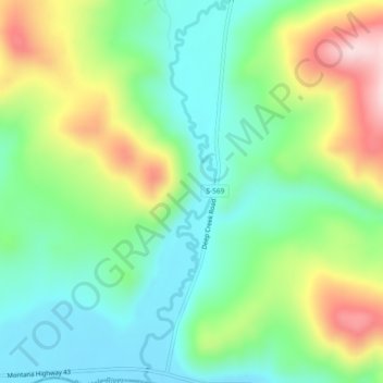
Name: Deep Creek Road topographic map, elevation, terrain.
Location: Deep Creek Road, Deer Lodge County, Montana, United States (45.88288 -113.11802 45.91524 -113.10726)
Average elevation: 1,868 m
Minimum elevation: 1,754 m
Maximum elevation: 2,086 m
Other topographic maps
Click on a map to view its topography, its elevation and its terrain.
Georgetown Lake
United States > Montana > Deer Lodge County
Georgetown Lake, Deer Lodge County, Montana, United States
Average elevation: 1,968 m
Anaconda
United States > Montana > Deer Lodge County
Anaconda, Deer Lodge County, Montana, 59711, United States
Average elevation: 1,753 m