Big Sky topographic map
Click on the map to display elevation.
Big Sky
Big Sky is located close to the Yellowstone National Park along the western edge of Gallatin County and eastern edge of Madison County, on U.S. Highway 191. It is approximately midway between West Yellowstone and Bozeman, being around 45 miles (72 km) by road from each. It sits within the Madison Range, with elevations in the CDP ranging from 5,900 feet (1,800 m) in Gallatin Canyon along U.S. 191 to over 11,000 feet (3,400 m) at the summit of Lone Mountain.
About this map
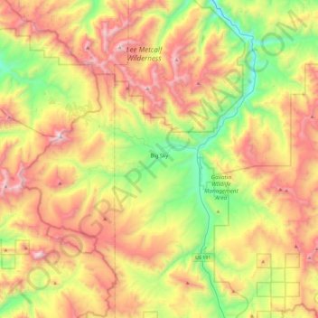
Name: Big Sky topographic map, elevation, terrain.
Location: Big Sky, Gallatin County, Montana, United States (45.13076 -111.49439 45.37939 -111.03817)
Average elevation: 2,439 m
Minimum elevation: 1,700 m
Maximum elevation: 3,382 m
Other topographic maps
Click on a map to view its topography, its elevation and its terrain.


Gallatin Gateway
United States > Montana > Gallatin County
Gallatin Gateway is a census-designated place (CDP) in Gallatin County, Montana, United States. As of the 2020 census, Gallatin Gateway had a population of 967. Elevation is 4,953 ft (1,510 m).
Average elevation: 1,519 m