Richmond topographic map
Interactive map
Click on the map to display elevation.
About this map
![Richmond topographic map, elevation, terrain](/pub/maps/relation/t93q/675b3/thumbnail.jpg)
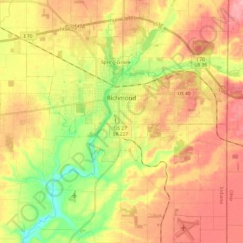
Name: Richmond topographic map, elevation, terrain.
Location: Richmond, Wayne County, Indiana, 47374, United States (39.74859 -84.96375 39.88259 -84.81367)
Average elevation: 314 m
Minimum elevation: 247 m
Maximum elevation: 372 m
Other topographic maps
Click on a map to view its topography, its elevation and its terrain.
![Spring Grove topographic map, elevation, terrain](/pub/maps/relation/kj18/lffz4/icon.jpg)
Spring Grove
United States > Indiana > Wayne County
Spring Grove, Wayne County, Indiana, United States
Average elevation: 300 m
![Boston topographic map, elevation, terrain](/pub/maps/relation/q35k/83kmt/icon.jpg)
Boston
United States > Indiana > Wayne County
Boston, Wayne County, Indiana, 47324, United States
Average elevation: 344 m
![Cambridge City topographic map, elevation, terrain](/pub/maps/relation/fjgp/1vh3q/icon.jpg)
Cambridge City
United States > Indiana > Wayne County
Cambridge City, Wayne County, Indiana, United States
Average elevation: 292 m
![Economy topographic map, elevation, terrain](/pub/maps/relation/nktj/gb257/icon.jpg)
Economy
United States > Indiana > Wayne County
Economy, Wayne County, Indiana, United States
Average elevation: 345 m
![Hagerstown topographic map, elevation, terrain](/pub/maps/relation/9nb3/fdg9m/icon.jpg)
Hagerstown
United States > Indiana > Wayne County
Hagerstown, Wayne County, Indiana, United States
Average elevation: 312 m