
Steglitz-Zehlendorf topographic map
Interactive map
Click on the map to display elevation.
About this map
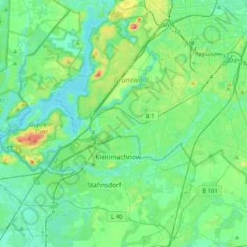
Name: Steglitz-Zehlendorf topographic map, elevation, terrain.
Location: Steglitz-Zehlendorf, Berlin, Germany (52.38723 13.08835 52.47184 13.37160)
Average elevation: 45 m
Minimum elevation: 26 m
Maximum elevation: 114 m
Other topographic maps
Click on a map to view its topography, its elevation and its terrain.
Friedrichshain-Kreuzberg
Friedrichshain-Kreuzberg, Berlin, Germany
Average elevation: 45 m
Charlottenburg-Wilmersdorf
Charlottenburg-Wilmersdorf, Berlin, Germany
Average elevation: 44 m
Volkspark Friedrichshain
Volkspark Friedrichshain, Barnimkiez, Friedrichshain, Friedrichshain-Kreuzberg, Berlin, 10249, Germany
Average elevation: 49 m
Charlottenburg
Charlottenburg, Charlottenburg-Wilmersdorf, Berlin, Germany
Average elevation: 41 m
Biesenhorster Sand
Biesenhorster Sand, Tangentiale Verbindung Ost, , Biesdorf, Marzahn-Hellersdorf, Berlin, 12683, Germany
Average elevation: 38 m
Volkspark am Weinberg
Volkspark am Weinberg, Spandauer Vorstadt, Mitte, Berlin, 10119, Germany
Average elevation: 47 m