
Siskiyou Gap topographic map
Interactive map
Click on the map to display elevation.
Siskiyou Gap
"The original pass crosses the divide between the Rogue and Klamath Rivers at a slight topographic notch formed by the geological contact between the older Siskiyou Mountains to the west and the younger volcanic Cascade Range to the east." (Jeffrey M. LaLande, retired, forest archaeologist, Rogue River-Siskiyou National Forest)
About this map
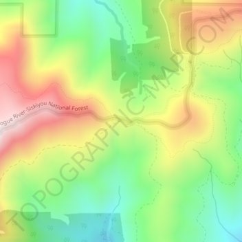
Name: Siskiyou Gap topographic map, elevation, terrain.
Location: Siskiyou Gap, Jackson County, Oregon, United States (42.05046 -122.80636 42.05056 -122.80626)
Average elevation: 1,746 m
Minimum elevation: 1,485 m
Maximum elevation: 2,076 m
Other topographic maps
Click on a map to view its topography, its elevation and its terrain.
Ashland
United States > Oregon > Jackson County
Ashland lies within Oregon's southwest interior climate zone, in which all but the higher-elevation sites are in the rain shadow of the Oregon Coast Range to the west. The largest urban areas in this zone in addition to Ashland are Medford and Grants Pass in the Rogue Valley, and Roseburg in the Umpqua River…
Average elevation: 774 m