
Blake topographic map
Click on the map to display elevation.
About this map
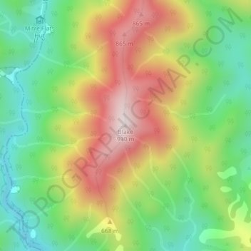
Name: Blake topographic map, elevation, terrain.
Location: Blake, Masterton District, Wellington, New Zealand (-40.84198 175.49092 -40.84188 175.49102)
Average elevation: 568 m
Minimum elevation: 308 m
Maximum elevation: 910 m
Wellington trails, hiking, mountain biking, running and outdoor activities
Other topographic maps
Click on a map to view its topography, its elevation and its terrain.
Miramar Peninsula
New Zealand > Wellington > Wellington City > Wellington
The peninsula is exposed to Wellington's prevailing northwest wind and the southerly wind. During southerly storms, big waves and swells batter the peninsula's rocky southern shore. The peninsula's topography, with its high ridges and small bays and coves, provides shelter from the wind in many places. On 15…
Average elevation: 20 m
Spenmoor Street Reserve
New Zealand > Wellington > Wellington City > Wellington
Average elevation: 151 m
Martinborough
New Zealand > Wellington > South Wairarapa District > Martinborough Community
Average elevation: 34 m