
Thank you for supporting this site ❤️
Make a donation
Make a donation
San Gabriel topographic map
Click on the map to display elevation.
Thank you for supporting this site ❤️
Make a donation
Make a donation
About this map
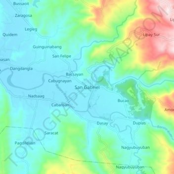
Name: San Gabriel topographic map, elevation, terrain.
Location: San Gabriel, La Union, Ilocos Region, 2513, Philippines (16.63389 120.36118 16.71389 120.44118)
Average elevation: 131 m
Minimum elevation: 4 m
Maximum elevation: 581 m
Thank you for supporting this site ❤️
Make a donation
Make a donation
Other topographic maps
Click on a map to view its topography, its elevation and its terrain.