
Thank you for supporting this site ❤️
Make a donation
Make a donation
Castelo Branco topographic map
Click on the map to display elevation.
Thank you for supporting this site ❤️
Make a donation
Make a donation
About this map
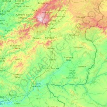
Name: Castelo Branco topographic map, elevation, terrain.
Location: Castelo Branco, Portugal (39.53736 -8.29312 40.41613 -6.86379)
Average elevation: 460 m
Minimum elevation: 24 m
Maximum elevation: 1,983 m
Thank you for supporting this site ❤️
Make a donation
Make a donation
Other topographic maps
Click on a map to view its topography, its elevation and its terrain.
Thank you for supporting this site ❤️
Make a donation
Make a donation
Thank you for supporting this site ❤️
Make a donation
Make a donation
Thank you for supporting this site ❤️
Make a donation
Make a donation