
Thank you for supporting this site ❤️
Make a donation
Make a donation
Montoggio topographic map
Click on the map to display elevation.
Thank you for supporting this site ❤️
Make a donation
Make a donation
About this map
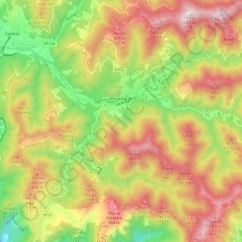
Name: Montoggio topographic map, elevation, terrain.
Location: Montoggio, Genoa, Liguria, 16026, Italy (44.47199 8.99652 44.54472 9.10164)
Average elevation: 644 m
Minimum elevation: 190 m
Maximum elevation: 1,090 m
Thank you for supporting this site ❤️
Make a donation
Make a donation
Other topographic maps
Click on a map to view its topography, its elevation and its terrain.
Thank you for supporting this site ❤️
Make a donation
Make a donation
Thank you for supporting this site ❤️
Make a donation
Make a donation
Thank you for supporting this site ❤️
Make a donation
Make a donation
Thank you for supporting this site ❤️
Make a donation
Make a donation
Thank you for supporting this site ❤️
Make a donation
Make a donation
Thank you for supporting this site ❤️
Make a donation
Make a donation
Thank you for supporting this site ❤️
Make a donation
Make a donation