
Thank you for supporting this site ❤️
Make a donation
Make a donation
Lempira topographic map
Click on the map to display elevation.
Thank you for supporting this site ❤️
Make a donation
Make a donation
About this map
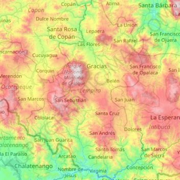
Name: Lempira topographic map, elevation, terrain.
Location: Lempira, Honduras (13.96332 -88.98200 14.94787 -88.31562)
Average elevation: 1,078 m
Minimum elevation: 105 m
Maximum elevation: 2,801 m
Thank you for supporting this site ❤️
Make a donation
Make a donation
Other topographic maps
Click on a map to view its topography, its elevation and its terrain.