
Thank you for supporting this site ❤️
Make a donation
Make a donation
Ward 5 topographic map
Click on the map to display elevation.
Thank you for supporting this site ❤️
Make a donation
Make a donation
About this map
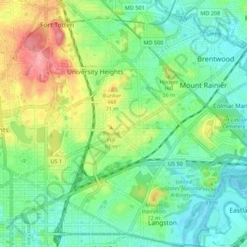
Name: Ward 5 topographic map, elevation, terrain.
Location: Ward 5, Washington, District of Columbia, United States (38.89708 -77.01926 38.95727 -76.94191)
Average elevation: 35 m
Minimum elevation: -4 m
Maximum elevation: 105 m
Thank you for supporting this site ❤️
Make a donation
Make a donation
Other topographic maps
Click on a map to view its topography, its elevation and its terrain.
Meridian Hill/Malcolm X Park
United States > District of Columbia > Washington
Average elevation: 44 m