
Sant Celoni topographic map
Interactive map
Click on the map to display elevation.
About this map
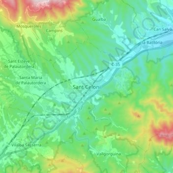
Name: Sant Celoni topographic map, elevation, terrain.
Location: Sant Celoni, Vallès Oriental, Barcelona, Catalonië, Spanje (41.64853 2.46297 41.73049 2.60880)
Average elevation: 269 m
Minimum elevation: 81 m
Maximum elevation: 857 m
Other topographic maps
Click on a map to view its topography, its elevation and its terrain.
Sant Sebastià de Montmajor
Spanje > Catalonië > Vallès Oriental > Caldes de Montbui
Sant Sebastià de Montmajor, Caldes de Montbui, Vallès Oriental, Barcelona, Catalonië, 08140, Spanje
Average elevation: 542 m