
Curtea topographic map
Interactive map
Click on the map to display elevation.
About this map
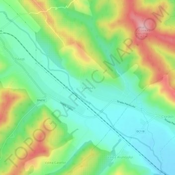
Name: Curtea topographic map, elevation, terrain.
Location: Curtea, Popești, Vâlcea, 247516, Rumänien (44.94405 24.11452 44.98405 24.15452)
Average elevation: 286 m
Minimum elevation: 224 m
Maximum elevation: 391 m
Other topographic maps
Click on a map to view its topography, its elevation and its terrain.
Râmnicu Vâlcea
Rumänien > Vâlcea > Râmnicu Vâlcea
Râmnicu Vâlcea, Vâlcea, 240140, Rumänien
Average elevation: 429 m