
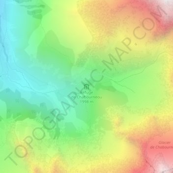
Refuge de Chabournéou topographic map
Interactive map
Click on the map to display elevation.
About this map
Name: Refuge de Chabournéou topographic map, elevation, terrain.
Average elevation: 2,297 m
Minimum elevation: 1,595 m
Maximum elevation: 3,288 m
Le refuge de Chabournéou se trouve dans le Valgaudemar, sur un promontoire rocheux sur les contreforts du Sirac, à 2 020 m d'altitude. L'accès se fait à pied, en 2 h, à partir d'un parking situé 500 mètres avant le chalet du Gioberney.
Other topographic maps
Click on a map to view its topography, its elevation and its terrain.
Refuge du Clot - Xavier Blanc
France > Provence-Alpes-Côte d'Azur > Hautes-Alpes > La Chapelle-en-Valgaudémar > Le Rif du Sap
Refuge du Clot - Xavier Blanc, D 480, Le Rif du Sap, La Chapelle-en-Valgaudémar, Gap, Hautes-Alpes, Provence-Alpes-Côte d'Azur, France métropolitaine, 05800, France
Average elevation: 1,797 m